Precision Aerial Surveys and Imaging in Dallas
Strategic Aerial Vantage in Texas
For any aerial survey requirement across Texas, including advanced magnetometer and electromagnetic surveys, LiDAR data acquisition, and precise GIS mapping, Dallas Helicopter Charters delivers comprehensive options. We capitalize on the inherent low-altitude flight and hover capabilities of helicopters to provide unparalleled data capture accuracy. Furthermore, our specialized aerial filming services integrate cutting-edge cinematography and photography technology, offering configurations such as door removal for handheld operations. For an elevated perspective on Texas infrastructure and terrain, our range of solutions is unmatched.

Aerial
Surveys
LiDAR, GIS Maps, FLIR, HD Video & More
Dallas Helicopter Charters provides robust aerial support for critical infrastructure assessment. From precision pipeline surveys to comprehensive right-of-way inspections and essential transmission line patrols, we facilitate access to the necessary aircraft and specialized equipment to ensure your project's accurate and timely completion across the Dallas-Fort Worth region and beyond.
High Tech Results
The Top Pilots in Texas, Today's Technology... Maximum Results.
Call 469-480-3306 Now!
Dallas Helicopter Charters provides the tools needed to complete your land surveys, utilizing the right equipment to provide the aerial photos that are often needed.
An effective aerial survey significantly streamlines right-of-way and site inspections, the acquisition of precise topographical data, and high-definition imagery for commercial and industrial projects. Helicopter surveys represent the optimal method for comprehensive analysis of the Texas terrain, facilitating meticulous pipeline leak detection, diagnosing transmission line anomalies, and documenting property assets with superior clarity. Dallas Helicopter Charters engineers bespoke photographic and remote sensing operations, meticulously customized to maximize both technical efficiency and financial viability, thereby yielding superior project outcomes.
Helicopters possess distinct aerodynamic advantages over fixed-wing aircraft for specialized aerial surveying, primarily their capacity for significantly lower and slower flight profiles. While Federal Aviation Administration regulations mandate fixed-wing aircraft maintain a minimum altitude of 1,000 feet above the highest obstacle, helicopters can operate at substantially lower altitudes with greater precision. This capability also enables helicopters to inspect critically troublesome or hazardous zones, providing engineers with an otherwise unattainable perspective vital for comprehensive analysis.
There is no better way to conduct your visual survey, animal population counts, soil drainage analysis, ROW inspections, pipeline and transmission line inspections, and geographical surveys.

LiDAR Imaging
Light Detection and Ranging, or LiDAR, is a remote sensing method used to examine and measure Texas topography as well as objects, like vegetation, upon it.

Infrared Imaging
Thermographic IR cameras are used to detect radiation in the long-infrared range of the electromagnetic spectrum and produce images of that radiation, called thermograms.
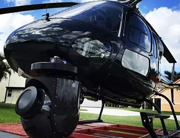
HD Video Gimbal Capture
Modern HD and 4K cameras can be mounted to helicopters, using the proper STCs, with a gimbal to stabilize photos & videos for detailed results.

Cutting-Edge Aerial Filming and Videography Solutions
For expert camera work in the Dallas Sky
Get a Fast, free QuoteDallas Aerial Cinematography
Dallas Helicopter Charters provides access to comprehensive resources for professional-grade aerial cinematography across Texas. Our network offers cutting-edge technology for custom shoots, featuring advanced gyro-stabilized camera mounts such as Tyler Mounts, Wescam, Cineflex, Pictorvision, and SpaceCam. These systems are compatible with industry-leading specialty cameras, including Cineflex HD, RED Epic, and Arri Alexa, alongside 3D and experimental camera setups. We support all facets of your production goals, from air-to-air to ground-to-air shots. Our operational support ensures seamless collaboration with aerial DPs and directors, delivering the precise visual results required. Specializing in helicopter support for both still and motion photography, Dallas Helicopter Charters facilitates a vast array of media-related operations throughout Texas, encompassing film, television, documentaries, promotional videos, commercials, aerial props, disaster relief for broadcast networks, and comprehensive coverage of historical and major sporting events with diverse aircraft options.
Call Us Today at 469-480-3306 for a Free Quote
Contact Us
Aerial Photos
Hand-held or Mounted OpTions in Dallas
We will help you get the right equipment for your aerial photography project! Call 469-480-3306 today to get a fast, free quote.
The Most Options for Photography
The striking landscapes and expansive vistas across Texas are optimally captured from an aerial perspective. Discover the potential of our specialized aerial photography charters, meticulously designed to surpass your expectations and assist in materializing your precise visual concepts. Dallas Helicopter Charters is equipped to offer clients highly cost-effective photographic opportunities of this caliber within Texas. Many helicopters can be configured for door-off operations to facilitate handheld projects; for enhanced stability and precision, please inquire about our advanced gyro-stabilized mount options.
Superior Service
Every one of our customers gets a dedicated helicopter expert to assist with flight plans, tech loadouts, production logistics, project schedules, and other demands.
Over 500 Aircraft
Our network of direct air partners extends well beyond Dallas, Texas. This allows us to offer a wide range of solutions for even the most sophisticated projects.
The Best Equipment
From high-tech sensors like LiDAR, FLIR, and GIS to HD cameras and movie production gimbals, we're here to make your job as easy as possible.